How to measure distances on Google Maps
– best Ai uses and Ai related updates, fresh and up to date Ai technologies and how to use Ai tools!

All about Google
Google Maps is known as one of the GPS applications most used by drivers, however, the platform also offers several other features, such as the possibility of drawing a straight line on the map and measuring the distance from one point to another. The technique, in addition to being curious, can be useful for those who want to obtain an average of the distance or proximity between different places.
Next, check out how to measure distances on Google Maps using the cell phone app or via a browser on your PC. The function is free and available to any user, regardless of whether that person has a Google account or not.
How to measure distances on Google Maps on your cell phone
Time required: 2 minutes
- Access the application
On the desktop home page, search for the Google Maps application and select it to open it;

- Find your desired location
When the app opens, click on the search bar, type the desired location and click on it;
- Select the measurement point
The chosen place will open and a red dot will appear, indicating the exact location. Click and hold this red dot until the white menu page rises and occupies the screen; then, drag the screen down and click on the “Measure distance” button;
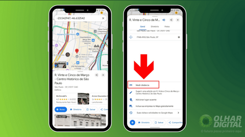
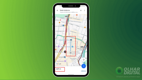
- Measure the distance
Finally, a black circle will appear and just drag the screen to start measuring the distance from one point to another.


Read more:
How to measure distances on Google Maps on your computer
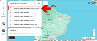
- The first thing to do is go to the official Google Maps website, clicking here;
- Then, use the search bar to find the desired location on the map;
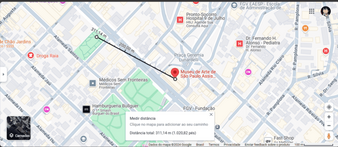
- Rest the mouse arrow over the desired location, right-click and select the “Measure distance” option. A little black dot will then appear, right above the location you chose;
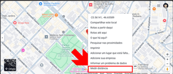
- Finally, once the black dot is available, click anywhere else on the map with the mouse and a straight line will appear, measuring the distance between meters and kilometers.
How to measure distances on Google Maps
Follow AFRILATEST on Google News and receive alerts for the main trending Law and layers near you, accident lawyers, insurance lawyer, robotic Lawyer and lots more! How to measure distances on Google Maps
SHARE POST AND EARN REWARDS:
Join our Audience reward campaign and make money reading articles, shares, likes and comment >> Join reward Program
FIRST TIME REACTIONS:
Be the first to leave us a comment – How to measure distances on Google Maps
, down the comment section. click allow to follow this topic and get firsthand daily updates.
JOIN US ON OUR SOCIAL MEDIA: << FACEBOOK >> | << WHATSAPP >> | << TELEGRAM >> | << TWITTER >
How to measure distances on Google Maps